Sirielle Art
  • Intro
  • Portfolio
    • Other Galleries
  • Maps
  • Arda
    • The Age of Stars
    • The I Age
    • The II Age
    • Quendi & Eldar
    • Arda Animation >
      • Nightfall
      • Losgar
      • Lost
    • Tolkien Fandom
    • Archive
  • Prints
  • About

Beleriand & Gondolin


Maps to accompany reading of The Silmarillion by J.R.R. Tolkien. Personal projects, digital.
Picture
Gondolin & Tuor, WiP 2023

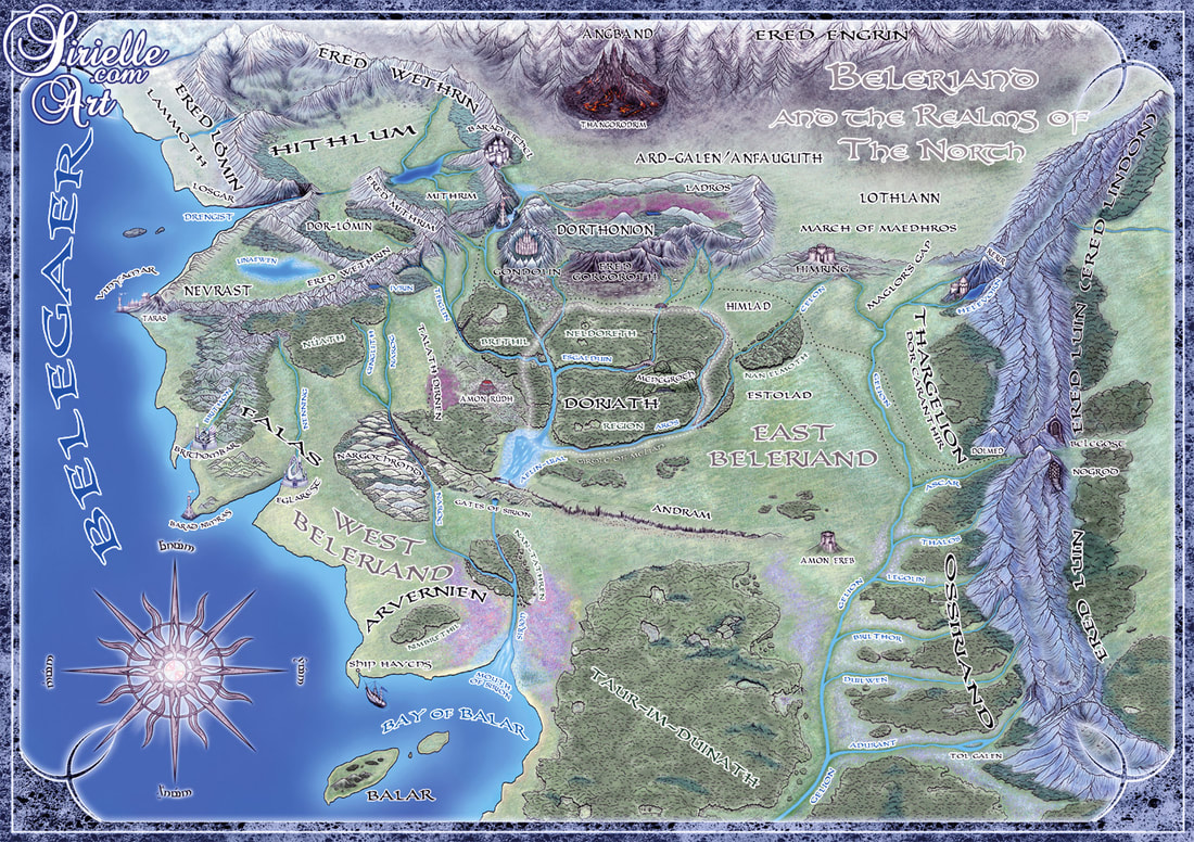
Beleriand and the Realms of the North

Picture
Beleriand and Realms of The North | Photoshop 2013
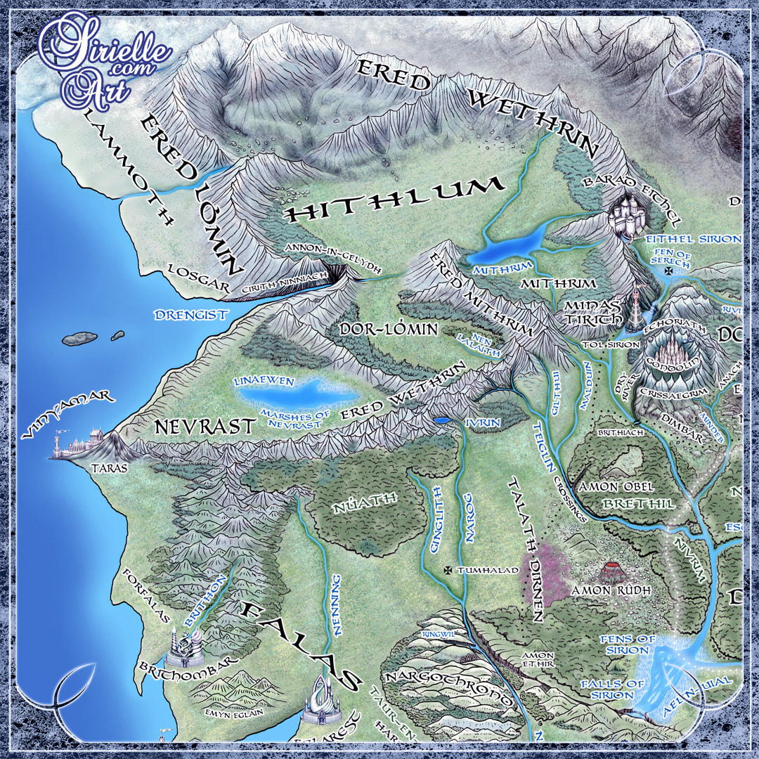
Picture Beleriand and Realms of The North (detail)
Beleriand and Realms of The North (detail) | Photoshop 2013, updated 2023
:: Beleriand: see more details & variants ::

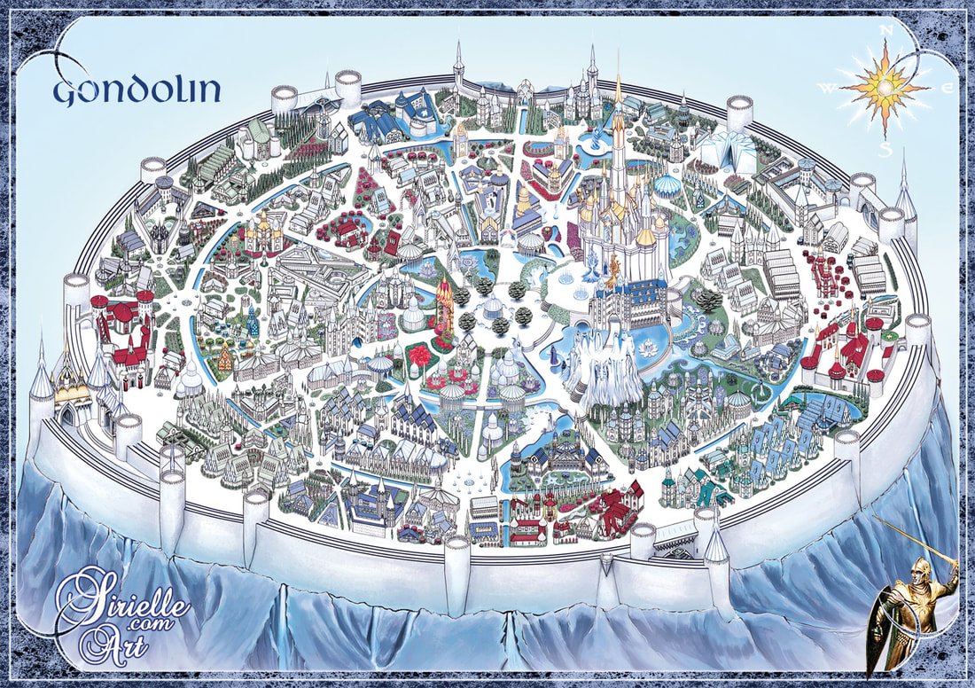
Gondolin the Hidden City

Picture Gondolin City Map
Gondolin City Map | Photoshop 2017/2022
As the the map of Beleriand done with support of my favorite Tolkien loremasters Ominous and M.L., but this time it is a result of guessing and constructing based on the map by Karen Wynn Fonstad from The Atlas of Middle-earth and descriptions from The Fall of Gondolin (The Book of Lost Tales II). Notes for Tolkien Geeks are in the bottom of the page.

Digital drawing done in Photoshop, 2017, colored in 2022/2023.
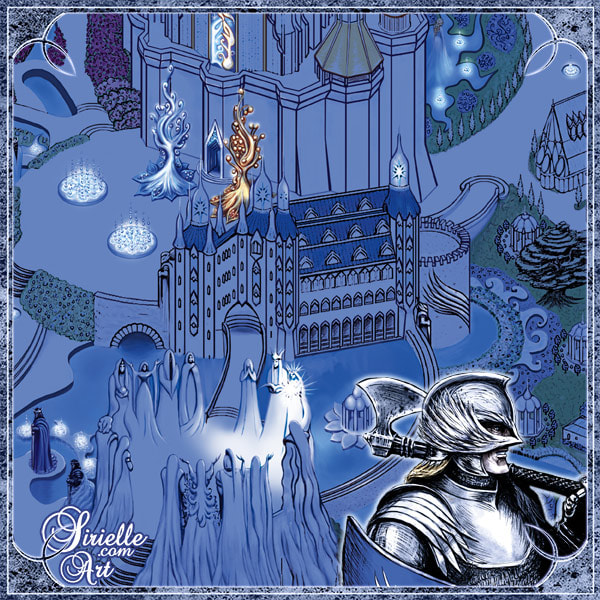
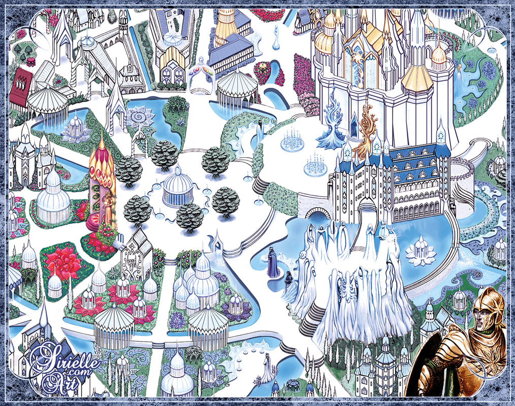
Picture Gondolin City Map (detail)
Gondolin City Map (detail) | Photoshop 2017/2023
Technical note: statues and more important buildings are larger, otherwise they would get lost in a sea of small houses/shapes. For the same reason usually a single house represents a city block. At first I started with much smaller buildings and more streets, but abandoned that idea, enlarged the buildings and continued from there. Each variant of the map has been enlarged and redrawn, so some details are different. Also there are more detailed elements on closeups that do not appear on the uncropped maps.
Picture
Gondolin City Map | Photoshop 2017/2022

Details

Picture
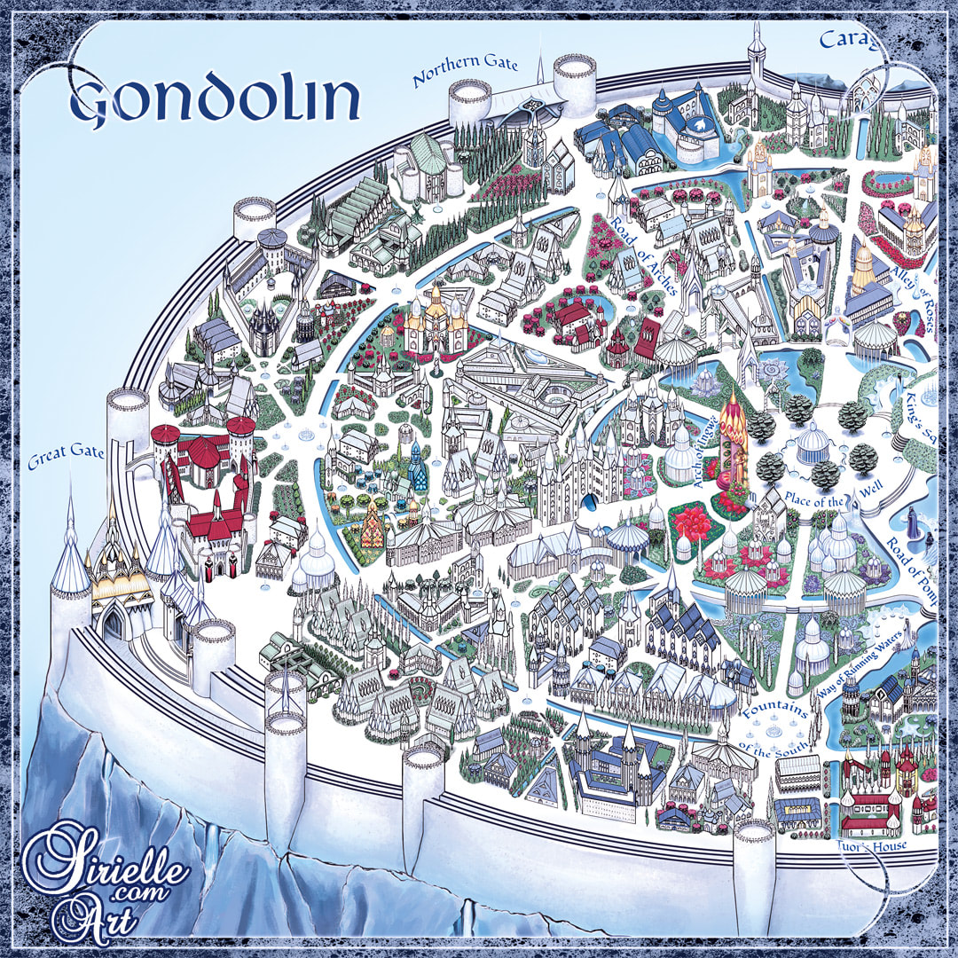
Gondolin City Map, street labels | Photoshop 2017/2023
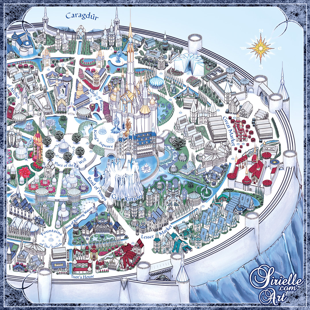
Picture
Gondolin City Map, street labels | Photoshop 2017/2023

Statues of the Elves

Closeups of statues of the Elven kings, Noldorin royal family members and the Valar.
Picture
Inwë Ingweron, the ruling King of the Vanyar (part of the Arch of Ingwë), Aredhel of the Noldor & Elenwë the Vanyar.
Most of the Elves are described in reference to Turgon, the king of Gondolin, and with time the king of all the Noldor in Beleriand. The names given in a different color are Quenya, other names are given in Sindarin. The dates of reign at the images refer to the First Age (F.A.) and the Years of the Trees (Y.T.).
Picture
Statues of the Kings of the Noldor ruling in different times (and a prince)

Notes for Tolkien Geeks

There were some contradictions in the text, so we had to choose one variant or construct something new. Like - is the hill on which the castle stands the highest point of the city or is it Gar Ainion? Was GA a building, a temple or a place? (I chose something between a place and a temple, as you see.) The roads' order/placement in some passages didn't match, either. In general it is based more on the text than the map from The Atlas of Middle-earth, though I started sketching looking at the atlas map. We also decided to exclude the King's Road visible on the atlas map since we didn't find it in the source text. Or to be precise - my loremasters didn't find it; I wasn't browsing the text but building The map in the atlas is also more simplified, representing a city too small to host the population of which 10,000 men Turgon brought to Nirnaeth Arnoediad. Those 10,000 men probably had families in the city and there must have been other guards, soldiers and civilians who didn't go to the war, so the city had to be bigger. The city I drew is still too small, but I left some space to build more houses.
Picture
City levels from the lowest and largest area #1, more or less flat, up to the highest #5 spot: Gar Ainion.
According to the text Noldorin architects flattened the whole hill of Amon Gwareth, leaving only the higher top for the king's castle, thus the city is more or less flat and easy to walk. But according to the text Gar Ainion was also the highest point in the city - both the King's Place and GA are being described as the highest points in the city (though in different text passages), so I decided GA was the higher of the two, and was another natural remnant of the original hill left. Canals with water flow from the well/spring in the center - the Place of the Well / Square of the Folk Well - and fall outside the city walls; more than I drew.
Picture
Statues of the Valar at Gar Ainion and the Noldor by the fountains below.
I moved the Tower of the King from the center of King's place to the castle, so it is the tallest of the castle towers. There was no way to do it as a stand alone tower in a way I would like it. The trees Glingal and Belthil, which Turgon made himself in memory of the Two Trees of Valinor, stand on both sides of the king's castle. It looks like they were made of metal, with gold for Glingal and silver for Belthil. There were also two deep fountains on the King's Square - "The fountains shot twenty-seven fathoms into the air (50m), and white birds dwelt in the trees, singing beautiful songs." It was probably one of those fountains where Ecthelion died in a duel with Gothmog (drowning the balrog in it).
Picture
Belthil and Glingal
I couldn't decide if the city was parted with walls inside (being built up of many smaller walled cities) or had an open plan inside of the great wall guarding it. Also what style do I really want for the buildings? Finally I chose the option of an open city, a huge park with villas and palaces and castles inside. There is a fortress for every of the twelve houses inside of it; the houses serve as military centers in the city. Placement of the houses is hypothetical, as I remember only the House of the Harp is clearly described as being north of the Lesser Market, so this one is more or less canonical. Houses are placed on the outer parts of the city and a few in the center - should citizens need to hide behind walls there is always a fortress in the neighborhood. Of course this will mean nothing when facing dragons... but there were no dragons when they built it.
Picture
There are only 2 gates on the atlas map and an extra place/fortification on its south which we decided to skip. Again there was no description of it in the sources. There are usually gates/roads close to markets so we decided to add the two other gates to have one gate for each side of the world. Noldor would like such symmetry, I believe, even if they rarely used the extra gates. The Main gate had the best uphill approach, while the Northern gate with narrow approach was closest to the mine of Anghabar in the North, so these two gates were used most often. This is one of reasons why I placed the House of the Mole in the NW part of the city - Maeglin would prefer to be close to the Northern gate I guess; and at the same time not too close to Tuor.
Picture
Placement of Tuor's house is based on the text, but could be in any of the houses close to the towers on the southern wall and the fountains. Ecthelion got his fortress close to the Fountains of the South since musicians used to dwell there. The Hammer of Wrath got the first place near the Main Gate since they were most eager to defend Gondolin and fight the enemy. The richest of the houses - the Heavenly Arch - got its place close to the king's castle, as did The Wing which I imagine being the king's guard, right after the king's own men.

Idril's secret passage is not on the map.

Picture of an art print
​Prints on demand ​available at:
INPRNT
and Redbubble

Powered by Create your own unique website with customizable templates.
  • Intro
  • Portfolio
    • Other Galleries
  • Maps
  • Arda
    • The Age of Stars
    • The I Age
    • The II Age
    • Quendi & Eldar
    • Arda Animation >
      • Nightfall
      • Losgar
      • Lost
    • Tolkien Fandom
    • Archive
  • Prints
  • About